The weather on the Pembrokeshire coast has suddenly turned beautifully sunny and warm. The sea is sparkling and flat as a pancake, so for the first time since last September we got the kayaks out and went for a little paddle.
Photo: Mike Howe
Kayaking gives you such a different perspective on the landscape and seascape around you. This sea cave cannot be seen from the surrounding cliffs, and as well as being very beautiful, it is also a special place for another reason which I will elaborate on later.
Photo: Mike Howe
And with 186 miles of coastline to choose from, all we need is a half decent summer for the first time in years and we’ll be out there exploring once again, I’ll even get the fishing lines out.
I mentioned in my post “The Old Road to Nowhere” earlier this month that I would be doing more conservation management planning work at a magnificent place in North Wales this week, and so I have. It’s a place called Dolmelynllyn (I can’t even begin to explain here how you should pronounce that, you need to hear it) and I wanted to share with you one of the best features of the estate – the magnificent Rhaeadr Ddu waterfalls (The Black Falls), and once again I am very lucky to have Mike Alexanders photographs for the purpose (the 2 Mikes work closely on a lot of these projects!).
Photo: Mike Alexander
The impressive falls have a drop of around 60 feet and take their name from the slab of black rock over which the water cascades. They are surrounded by our version of a rain forest, the Atlantic Oakwoods.
Photo: Mike Alexander – Wilsons Filmy Fern
The relatively warm, wet microclimate has provided perfect conditions for some of the rarest ferns, mosses and lichens in the whole of the UK, making this an internationally important site for nature conservation. The woods are also fabulous habitat for the relatively rare lesser horseshoe and brown long-eared bats.
Photo: Mike Alexander – Lichens growing on trees
The seasons bring changes to the waterfalls, from gentle, deeply relaxing summer flows to raging torrents in the heavy rains of autumn, to the occasional deep freeze of winter….
Photo: Mike AlexanderPhoto: Mike AlexanderPhoto: Mike Alexander
If you keep climbing up the winding path alongside the falls, and make your way up through the woodland, you eventually come up on top where you are rewarded with a wonderful view of the whole estate.
Photo: Mike Alexander
I hope that the work we are doing here will ensure that it remains intact and beautiful for thousands of people to enjoy into the future, and for the special wildlife to continue to thrive.
Last week I was supposed to be visiting Skomer Island for the day with a number of colleagues and friends to discuss management issues. Skomer (Welsh: Ynys Sgomer) is an island off the coast of Pembrokeshire in southwestern Wales and you get to it by boat at the end of the road that passes our house.
Photo: Mike Alexander
It is well known for its wildlife: a third of the world population of Manx Shearwaters nest on the island, and the Atlantic Puffin colony is the largest in southern Britain. These birds spend the autumn and winter months at sea in the South Atlantic and return to Skomer each year to breed in dis-used rabbit burrows (rabbits were introduced to the island as a food source in the 14th century). There are numerous archaeological remains on the island, from stone circles, standing stones and prehistoric houses.
Puffins on Skomer Island, Pembrokeshire Photo: Mike Alexander
Unfortunately on the day of departure we were being battered by storm force south-westerly winds, and as a result the boat, the “Dale Princess”, was unable to make the crossing safely, so we couldn’t go.
Photo: Mike AlexanderPhoto: Mike Alexander
Fortunately my friend Mike Alexander, who gives me all these wonderful photographs to show to you, was the warden on the island from 1976 to 1986, and so he has given me more photos of Skomer to share. I think you’ll agree it is a pretty lovely looking place. I’ll wait for better weather and sea conditions and get over there later in the year.
Sadly I only visited the badlands of North Dakota very briefly many years ago. Even more sadly my camera wasn’t working at the time so I wasn’t able to record the hauntingly beautiful landscape, so I did the next best thing and wrote some music about it instead…..
Of course the music of any landscape is completely abstract, so for every person that can identify with it, there will be many more who cannot – we all have different senses and points of reference, which is a very good thing.
This music is also dedicated to Yellow Bird, Kent, Grover and Dan, “The Wolf at Twilight”
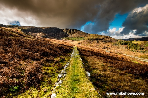
High up on the slopes of the Rhinogau (Rin-og-i), an isolated, rugged range of mountains forming much of the Harlech Dome in North Wales, lies a 19th century gold mining complex. All that remains of the hard toil of the men and women of the time are some deep,cavernous mine shafts which drip with the rain from the mountains, a few ruined buildings and the old track that was used to transport the rock for processing.
Photo: Mike Alexander
Since all the industry left the hillside, nature has quietly taken over again, so that now the only sound you hear up there is the sighing of the wind and the throaty call of the raven in his craggy domain. The noise and disruption of the past is long gone, along with all the stories of the people who worked this land in order to provide a living for their families.
The land is now cared for by the National Trust, and I have had the privilege to write the plan for its future conservation. There’s plenty more to see at this place, and I’ll update you as I go. I’ll be back there next week.
I have been exceptionally lucky recently to have been asked to prepare a conservation management plan for the estate at Dinefwr (Din-ev-or) near Llandeilo in West Wales, which is owned and cared for by the National Trust.
It is quite a difficult task to paint a verbal picture of Dinefwr and it isn’t possible to convey the importance of the place in strictly factual terms. It’s only when you are lucky enough to visit Dinefwr that the sheer unusual beauty of the place strikes you in a way that the words that you have read cannot. It is a very, very special place indeed.
Dinefwr is of exceptional significance for its archaeology, designed landscape and buildings. The present day landscape was set out by George Rice and his wife Cecil with some assistance from Lancelot ’Capability’ Brown in the second half of the 18th century. It has been widely admired ever since with impressions recorded by means of painting, sketching and the written word – it even appeared on a dinner plate, part of a service commissioned by Catherine the Great.
Today the park is widely acknowledged to be one of the finest designed landscapes in the UK. At its centre is Newton House, originally constructed in the 17th century to a simple but elegant design, it was encased in limestone to a Venetian-gothic design in the 1850s.
Photo: Mike Alexander
Trees and open grassland are so important to the appearance and aesthetic qualities of Dinefwr’s landscape and they were deliberately set out as part of the landscape design, with most of the trees planted on the higher ground and the grassland occupying the valleys and the areas immediately adjacent to the house and the main drive.
Archaeological surveys have, inevitably, revealed evidence of earlier landscapes including the defensive structures of an Iron Age fort and most remarkable of all, two overlapping Roman forts. Faint earthworks mark the outlines of tracks and field boundaries that predated the construction of the deer park in the middle of the 17th century.
One of the most significant archaeological monuments in the park is Dinefwr Castle. The 12th century stone buildings and walls seen today apparently replaced an earlier timber structure dating to the 8th century. This castle was the capital of most of west and south Wales in the 12th century so the surrounding woodland and park must conceal evidence of medieval tracks and paths.
The park is well known for its fallow deer and, in particular, its white park cattle – a rare breed restored to the park in 1992 after a long absence, but that can be traced back to Dinefwr from at least 1000 years ago.Both the deer and the cattle are integral to the historic park in their own right, but also because they maintain a complex mosaic of ancient grassland habitats.
Ancient white park cattle Photo: Mike AlexanderFallow deer herd Photo: Mike Alexander
One of the most striking features of the grassland in the deer park is the abundance of yellow meadow ant hills, which indicates how undisturbed this grassland has been for centuries.
Photo: Mike Alexander
In some parts of the park there are remnants of medieval woodland featuring many ancient trees that are at least 400 years old. And at its core, this wood pasture is dominated by nearly 300 huge oak trees, including some of the oldest and largest trees in the UK – one, the Castle Oak, is thought to be over 700 years old.
700 year old oak tree Photo: Mike Alexander
Dinefwr’s ancient trees, important in their own right, are host to a remarkable assemblage of wood decay invertebrates including 400 “saproxylic” beetle species, 26 of which are classified as nationally scarce. More than 160 species of lichen have been recorded in the park, several of which indicate a long history of ecological continuity.
The assemblage of breeding birds at Dinefwr is very impressive, and some of the most important are the lesser spotted woodpecker, an increasingly rare species in the UK, as are the green woodpeckers, which thrive on the impressive colonies of yellow meadow ants, conspicuous by the presence of hundreds of ant hills in the deer park grassland. Other notable bird species breeding in the woodlands include tawny owl, tree creeper, sparrowhawk, tree sparrow, jay, long-tailed tit and pied flycatcher.
On the lakes, ponds and ditches of the Towy floodplain greylag geese, Canada geese, swan, widgeon, goldeneye, heron and snipe amongst many others can been found year round.
Although it is rarely seen, the remnants of a past forested landscape, where there is now sea and beach, is a very interesting feature and teaches us about past sea level rise and our recent glacial history, and makes sense of some of the archaeological remains we find around our coastline in West Wales.
At the end of the last glaciation the sea level was much lower than it is today because so much water was still locked up in the ice sheets to the north of Britain. As the climate warmed forests became established on land that had been tundra for thousands of years, and this forest extended far out beyond where sea level is today. Gradually as temperatures rose, the sea ice to the south of the arctic circle melted and sea levels rose, submerging much of the coastal forests.
In some places this action was very rapid and sand covered and then preserved the remains. After heavy storms and at very low tides, peat or the stumps of these forest trees may be seen at places along the Welsh coast, particularly, in Pembrokeshire, at Newgale and Freshwater West.
Photo: Mike Alexander – The remains of a Scots pine trunk on the beach
The remains of animals and Mesolithic tools have been found in these deposits. These include an Auroch, which is an ancient cow and is the ancestor of all modern cows, a pig, a roe deer, a red deer antler and a brown bear jaw.
At Lydstep Haven, a pair of broken flint microliths were found by the neck vertebrae of a pig. This pig may have been injured, but not caught by its Mesolithic hunters and subsequently died in the forest. A tree trunk fell on its remains, preserving it, and the microliths in situ. This find has been dated to about 6000 BC.
Geraldus Cambrensis (Gerald of Wales ) noted the uncovered submerged forest, during his tour of Wales in AD 1188.
‘We then passed over Newgale sands at which place a very remarkable circumstance occurred. The sandy shores of south Wales laid bare by the extraordinary violence of a storm, the surface of the earth, which had been covered for many ages, reappeared, and discovered the trunk of trees cut off, standing in the very sea itself, the strokes of the hatchet appearing as if made only yesterday. The soil was very black and the wood-like ebony. This looked like a grove cut down, perhaps at the time of the deluge, or not long after.’
We cannot be sure whether the marks he saw were made by a stone axe. It is certainly possible, since stone axes were in use before the forests were submerged between about 6000 and 5000 BC.
He made these observations 800 years ago and similar observations are the basis for medieval traditions about the Cantref Gwaelodd – ‘the lost lands of Wales.’
This is what the beautiful coastline looks like today….
I have been lucky enough to be able to devote most of my working life to learning about nature and wildlife, and then learning about how best to look after it. Of course the old adage is really true here, the more you learn the more you realise how much you don’t know. But if you’ll allow me to put that to one side for a moment, one of the most surprising things that I have learned is that, contrary to what people might think, looking after (or conserving) nature is less about spending your time studying and managing wildlife and much more to do with spending your time dealing with people. If you don’t have the ability to communicate with people, then your ability to conserve wildlife is seriously diminished.
This is because in most places in the world, people own or have a claim to the land that your wildlife is trying to share, and if those people don’t care about the wildlife, then they are unlikely to let you conserve it, particularly if there is no economic reason for them to do so. More often than not, if you can convince people that the land they have is precious, and the wildlife living there is of intrinsic value, then you’ve got a reasonable chance of getting them to care. What was it Leopold said? “When we see land as a community to which we belong, we may begin to use it with love and respect”. Well that’s kind of the sentiment that you’re trying to foster, and of course there are a lot of people who already feel that way, so it isn’t always an uphill struggle.
One of my more recent jobs was to write a management plan for a beautiful farm in the Snowdonia National Park in North Wales which had been acquired by the National Trust, with the help of 20,000 donations from the public and weighty celebrity backing in the form of Welsh Hollywood star Catherine Zeta Jones. The National Trust have the job of conserving places like this in perpetuity, and having a management plan is an important tool in that process.
Having spent some time at the farm and absorbed some of it into my bones, my first task was to communicate the beauty and wonder of the place so that people could begin to appreciate its value. It was inspirational to help with this work, and the added benefit was the inspiration for my music. This is what I wrote……
“There are some places that, when you walk into them for the first time, you know are special, places that make you pause in wonder, places that most of us rarely come across in our day to day lives. Llyndy Isaf is one of these.
It isn’t that Llyndy Isaf is more special than anywhere in the surrounding landscape. The farm lies within Nant Gwynant, which is one of the most dramatic and beautiful valleys in Wales. Its northern slopes rise to the summit of our highest mountain, Yr Wyddfa (Snowdon) and to the south are the relatively undisturbed hills of Moel y Dyniewyd and the Moelwynion range. The Afon Glaslyn river runs through two majestic lakes, Llyn Gwynant and Llyn Dinas, and below the picturesque village of Beddgelert, it tumbles down to sea-level through the positively alpine Aberglaslyn Pass. This is a world-class landscape and is at the very heart of the Snowdonia National Park.
Photo: Mike Alexander
Ask any two people what they think is special about Llyndy Isaf and they will give similar but varying answers, “specialness” is very much in the eye of the beholder. Natural beauty is one term that can be used to describe much of it, and as we shall see as we gather our thoughts on how this place should be cared for in the future, the features that comprise natural beauty are many and varied.
One feeling that dawns on a person at Llyndy Isaf is that this is a very old place. The valleys, hills, streams and lake all feel like they have been around for a very long time, and the rocks from which they have been carved, much, much longer. Even some of the trees are gnarled and twisted by many years of growth in rain, wind, cold and, from time to time, luxurious warmth. And yet there is much that is youthful.
The feathery growth of new young trees, the first spring flowers of dog violet and bluebell tentatively raising their heads through the cold, wet, moss clad ground. This is an unusual place of great antiquity and brand new life.
The unmistakable influence of human endeavour, the farm buildings, the sheep folds and pens, the field boundary walls and fences speak of hundreds, if not thousands of years of toil to provide food and shelter for countless generations of people. Many of these features of the landscape are regarded as our heritage, and it has been, and continues to be, the way people interact with that heritage that defines our culture.
Photo: Mike Alexander
To the untrained or uninitiated eye this place looks wild, wonderful and natural. Well it is wild and wonderful, but it isn’t natural. This, above all else, is a cultural landscape. The rich array of habitats, the woodlands, grasslands and heathlands are as much cultural landscape features as are the buildings and walls.
Like anywhere else, Wales’s landscapes have emerged from people’s interaction with natural resources under changing environmental and economic conditions through time. This continues. But while the character and form of these areas can be explained, it is much harder to predict how they will change in the future.
If we apply international definitions of wilderness, there are no wilderness areas in Wales, and there is no potential for such areas. The common misconception of wilderness relates to people’s sense of exposure to the natural elements and absence of built development, not to wild untouched places. When people understand the history of human settlements, agriculture, forestry and water management, the human influence becomes obvious everywhere.
Photo: Mike Alexander
In its place, we have a glorious living landscape, the wildlife of which has been shaped over thousands of years as the mainly unintentional by-product of generations of people toiling to provide a living for their families. These activities have also left us with a landscape covered in wonderful historic buildings and monuments. This is our cultural landscape and it is special and precious; its valuesshould be celebrated and not diminished through comparison with something that happens elsewhere.
The land at Llyndy Isaf is a magnificent example of this, and now it falls to the National Trust to take responsibility, on behalf of so many people who helped to purchase the farm, for how this place is to be cared for into the future”.
The photographs show what a beautiful place it is, and so inspiration for music was plentiful. This song was inspired by the magic of nature and also by the writings of Aldo Leopold, who proposed the “Round River” metaphor for life’s energy from the ground, through plants and animals and back into the ground in a never ending circle.